
Height From Elevation⚠ unverified
Trigonometry / Applications · Height from distance and angle of elevation
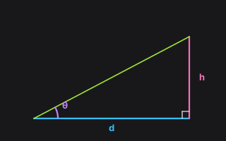
Parameters
| Input | Symbol | Unit | Default | Description |
|---|---|---|---|---|
| distance | d | m | 10 | Horizontal distance |
| theta | θ | degree | 45 | Angle of elevation |
| Output | Symbol | Unit | Description |
|---|---|---|---|
| h | h | m | Height |
The science & history
Understanding the Parameters
- d (m) — Horizontal distance.
- θ (degree) — Angle of elevation.
- Output h (m) — Height.
How to Calculate
- Enter Horizontal distance as
distance(default 10 m). Use the unit menu when you need a different unit. - Enter Angle of elevation as
theta(default 45 degree). Use the unit menu when you need a different unit. - Click Calculate. The card evaluates $h=d\tan\theta$ and shows the result in the declared output unit; Result in (when present) converts that number.
The Science: A Rigorous Derivation (Approaching a Proof)
Angle of elevation converts a surveyed baseline into a height by $\tan\theta = h/d$. Simple harmonic motion $x = A\cos(\omega t+\phi)$ is the projection of uniform circular motion: period $2\pi/\omega$, peak speed $A\omega$. Both are the right-triangle (or unit-circle) definitions applied to a physical situation, not new trigonometry.
Dimensional check. The declared output unit is m; ToolBox evaluates the
formula in SI (radians internally for every trigonometric call) and python-calc converts to
the unit on the card.
History and Development
Height-and-distance problems are in every early-modern practical geometry (Gemma Frisius, the surveyor's theodolite). SHM is Huygens and Newton; the circular-motion projection picture is already in Galileo's notes on the pendulum.
Related Concepts: Distance From Elevation, SHM Period, SHM Max Speed